World's Largest Bible Prophecy Bookstore
| Then and Now Bible Maps |
|
| Main |
About Us
FAQ
Privacy Policy
Contact Us
| Products |
DVDs
VHS
Charts
Audio Books
| Orders |
Secure Order Form
Mail & Fax Orders
Shipping Rates
|
Mastercard Visa, Discover * * * Phone: 1-980-434-5708 * * * |
| Also See: Clarence Larkin Charts & Transparencies | Misc. Full-Color Charts | Books of Charts | Temple | Tabernacle | |
|---|
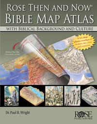
ROSE THEN AND NOW BIBLE MAP ATLAS WITH BIBLICAL BACKGROUND AND CULTURE
Dr. Paul H. Wright, 2012| $36.95 Retail $39.99 | Ships within 24 hours! |
The Best "Then and Now" Bible Atlas Ever — It has Features No Other Has!
- 120 stunning detailed Bible maps
- Clear plastic overlays of modern cities and countries so you know where Bible places are today.
- Incredible insights into the lives of 30 important Bible characters. This atlas focuses on people – not regions -- and how the geography affected their lives and decisions.
For example:
- Know how David's clever understanding of geography and politics led to his marriage with Ahinoam of Jezreel.
- Discover why Naomi, in the Book of Ruth, couldn't just move back to Bethlehem after her husband's death and use his land again.
- Find out why Moses and the Children of Israel took the long southern trek from Egypt to the Promised Land, rather than the direct route.
This atlas gives you incredible insights into your favorite Bible stories. 272 pages, hardcover.
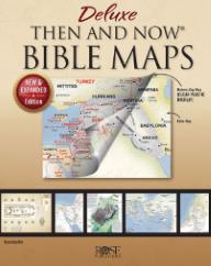
DELUXE THEN AND NOW BIBLE MAPS - New & Expanded Edition
Rose Publishing, 2020| $34.95 | Ships within 24 hours! |
The NEW and EXPANDED Edition of the best-selling Deluxe Then and Now Bible Maps! With more than 30 new pages of highly detailed relief maps, full-color illustrations, and diagrams, this book lets you see where places of the Bible are today. The clear plastic overlays show modern cities and countries on top of beautifully rendered relief Bible maps.
Connect the "Middle East" of the news with the Holy Land in Scripture! Clear plastic overlays show modern cities and countries on top of Bible maps relevant to the patriarchs, Jesus, Paul, and the early church. Expanded edition includes 30 new pages of charts, illustrations, diagrams, and more. Approx. 72 reproducible pages, 9.5" x 11.25" spiralbound hardcover.
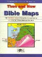
THEN AND NOW BIBLE MAPS
Rose Publishing, 1997| $19.95 | Ships within 24 hours! |
Now you can campare the places mentioned in the Bible with modern day cities and countries. Make Bible study even more interesting by showing where Bible places are today.

Then and Now Bible Maps give you full-color Bible maps with clear plastic overlays of modern cities and countries in this 20-page 8 1/2 X 11 spiral bound book. This fantastic map book contains all the following maps, along with time lines, and index:
- Old Testament Middle East Map
- Assyrian Empire 875-640 B.C.
- Babylonian Kingdom 600 B.C.
- Persian Empire 500 B.C.
- Holy Land - Old Testament 1300 B.C. Twelve Tribes
- Holy Land - New Testament
- Paul's Journeys A.D. 30-68
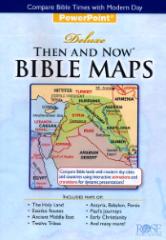
DELUXE THEN & NOW BIBLE MAPS POWERPOINT PRESENTATION - Revised Edition
CD for Windows or Macintoshes
Rose Publishing, 2017| $37.95 Retail $39.99 | Ships within 24 hours! |
This ready-to-use PowerPoint presentation assists you in showing your students where Bible places are today. The "then" maps show locations and regions as they were in Bible times. The "now" maps show modern-day borders and locations in red over the Bible times maps. CD Features:
- More than 50 "slide" frames.
- Printable handouts and worksheets.
- Show just one map or an entire series
- Journeys of Abraham, Joseph, and Jacob
- Judges and prophets
- The seven churches of Revelation
Computer System Requirements: To run this version of Deluxe PowerPoint Then and Now Bible Maps, you must have Microsoft PowerPoint 2007 or higher already installed on your computer (this CD does not come with PowerPoint application) and Adobe Acrobat Reader 9.0 or higher (if printing out the handouts), as well as -- Minimum for PCs: Intel Core 2 Duo or better, Windows XP or higher, 256-Color Monitor. Minimum for Macintoshes: Mac OS 10.6 or higher Intel Core 2 Duo or higher, 256-Color Monitor.
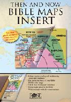
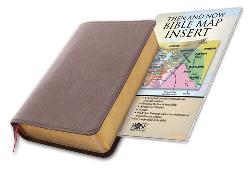
THEN AND NOW BIBLE MAPS INSERT
Rose Publishing, 2008| $16.95 | Ships within 24 hours! |
An ultra-thin Bible atlas that fits in the back of your Bible. This incredible full color 44-page Bible atlas has clear plastic overlays of modern-day cities and countries. Now you can have "Then and Now" Bible maps inside your Bible. Includes 44 pages; 8 plastic overlays; all maps in full color; larger print than other Bible map inserts; every major city in the Bible; a Bible time line; index; separate maps for each of Paul's Journeys. 5.5 x 8.5 inches.
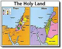
THE HOLY LAND - Then and Now Wall Chart
Rose Publishing| $15.95 | Ships within 24 hours! |
The Holy Land: Then and Now compares a Bible map of the Holy Land during Old Testament times side-by-side with a map of modern-day Holy Land. The clear, colorful map with large print provides a simple way of enhancing Old Testament stories of Moses, Joshua, the 12 Tribes, Joseph, the kings of Israel. Reproducible worksheets and teaching tips on back of this chart. Wall map size: 19.5” x 26” heavy chart paper, laminated.
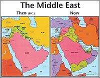
THE MIDDLE EAST - Then and Now Wall Chart
Rose Publishing| $15.95 | Ships within 24 hours! |
The Middle East: Then and Now compares a Bible map of the Middle East side-by-side with a modern-day map. The clear, colorful map with large print provides a simple way of enhancing many Old Testament Bible stories, including Abraham, Isaac, Jacob, Adam and Eve, Noah’s ark, the Tower of Babel, Daniel, and Esther. Reproducible worksheets and teaching tips on back of this chart. Wall map size: 19.5” x 26” heavy chart paper, laminated.
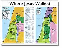
WHERE JESUS WALKED - Then and Now Wall Chart
Rose Publishing| $15.95 | Ships within 24 hours! |
Where Jesus Walked: Then and Now compares a Bible map of the lands where Jesus walked, side-by-side with modern-day cities and countries of the same area. Shows Bethlehem, Nazareth, Jerusalem, Jericho, the Jordan River, and every other place Jesus walked. Great for teaching the Gospels and the book of Acts. Reproducible worksheets and teaching tips on back of this chart. Wall map size: 19.5” x 26” heavy chart paper, laminated.
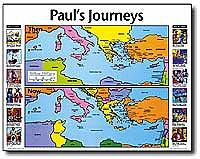
PAUL'S JOURNEYS - Then and Now Wall Chart
Rose Publishing| $15.95 | Ships within 24 hours! |
Paul's Journeys: Then and Now compares a Bible map of the lands where Paul traveled, side-by-side with a modern-day map of those same lands. The clear, colorful map provides a simple way of enhancing many New Testament Bible stories, including Paul's Journeys, Barnabas, Silas, the Road to Damascus, Peter, and the churches of Revelation. Reproducible worksheets and teaching tips on back of this chart. Wall map size: 19.5” x 26” heavy chart paper, laminated.
Copyright 2003-2026 by Cliffside Publishing House